

Egypt Protectorates
1- Ras Mohamed Egypt Protectorates Area and Tyran as well as Sanafir in South Sinai Governorate
Date of Announcement : 1983
Area : 850 km2 Type : World Heritage Egypt Protectorates Area
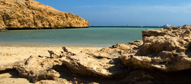
Distance from Cairo : 446 Km This protected Area is located at the meeting point of the Gulf of Suez and Aqaba Gulf.
The Eastern border of Ras Mohamed Protected Area is a rocky wall with the gulf water where there are coral reefs.
There is also the Mangrove channel which separates Ras Mohamed Peninsula from Elbayra Island at a length of approximately 250m.
Ras Mohamed Area is characterized by the coral shores existing in the depth of the water peripheral of Ras Mohamed and the extinct colored fish and Sea turtles as well as rare Sea Animals.
The Coral reefs surround Ras Mohamed from all its sea sides.
They have a unique formation which has a great impact on the natural life of the Area.
The land Falls or “earthquakes” formed water caves under the island.
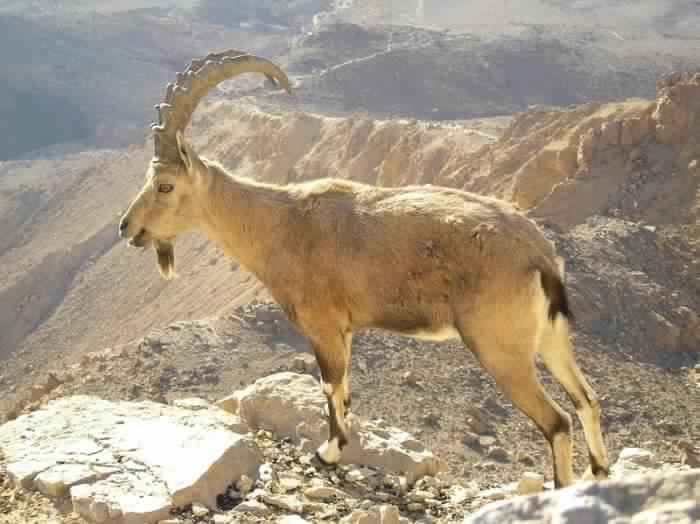
The Area is also a habitat for many important birds and animals such as: The Nubian ibex in the mountainous areas, small mammals, reptiles and insects that appear only at night.
The Area is also a habitat for many important birds such as herons and seagulls.
Tyran Island It is about 6 km far from the eastern coast of Sinai.
It is a floating coral reef Island. It consists of ancient granite basis rocks under a cover of sedimentary rocks.
The water sources of the Island are limited to winter rains and waterfalls that gather in the rocky holes formed by water rains and waterfalls(flood).
Sanafir Island It is located west of Tyran Island at a distance of 2.5Km.
There is an open bay that is suitable as a vessel yard in case of emergency.
2- Zaraniq protected Area and El Bardwaeel Marsh in the North Sinai Governorate
Date of Announcement : 1985
Area : 230 km2 Type : Wetland protected area and a natural restricted area for birds
Distance from Cairo : 300 km Zaraniq protected Area and El Bardaweel Marsh are key points for bird migration in the world since it is the first stop for the birds to have comfort and food after the trouble of the migration trip from Europe and Asia during the fall heading from African.
Some birds take this Area as a permanent habitat for living and reproduction.
Over 270 species of birds have been recorded in the area. .
Egypt Protectorates – They represent 14 classes.
The most important birds recorded are: Pelicans, herons storks, crestet lark , quail, white stork, lark, avocet , Hem Harrier Rail and falcon .
3- Coast marshes Area in Rafah North Sinai Governorate (Ahrash Egypt Protectorates) Date of Announcement : 1985 Area : 8 km2 Type : Developing resources protected area Distance from Cairo : 370 km The Marshes protected Area is characterized by the sand dunes, whose height is approximately is 60 m of the sea level.
They are covered by a high density of acacia trees, some tomorx trees, camphor trees, bushes, grass, pastoral and fodder plants, which make the Area a good resource of pastures , timber, and a shelter for animals and wild birds, They help stabilize sand dunes and warbers located within the framework of protection in order to maintain an important form of the Mediterranean coastal environments.
4-Elba Natural Egypt Protectorates Area in the Red Sea Governorate Date of Announcement : 1986 Area : 35600 km2 Type : National Park Protected Area Distance from Cairo: 1300 Km Elba natural Egypt Protectorates Area is located in the southern eastern part of the eastern desert.
Its mountains are located on the joint borders of Egypt and the Sudan on the Red Sea.
Elba Area has the following distinguished Ecosystem models:
1-Alshura and Qandeel Mangrove woods on the Coastal zones.
2-Limited areas of Coastal sand dunes covered with grass.
3-With grass sphere of coastal saline land ” Coastal Marshes”
4-Desert Coastal plains.
5- Coastal mountains and their surrounding hills where there are mist oasis.
In such environments there are the most types of Egyptian extinctionable animals, birds, reptiles, medical and wild plants.
Elba natural protected Area consists of the following :
1) Red Sea Islands and coastal mangrove woods.
2) Elabraq Area.
3) El Da’eeb area.
4) Elba Mountain.
5- Elomayed Natural Egypt Protectorates in Matrouh Governorate Date of Announcement : 1986 Area : 700 Km2 Type : Desert Area and vital peripheral Distance from Cairo : 300 km There are around 170 species of wild plants growing in different ecosystem, be they sand dunes or internal hills.
Studies showed that this wild plants have economic and medical benefits since there are about 70 species that can used for medical and thera peutical purposes like squall, wormwood, plantain, wood, sorrel.
There are also 60 species that can be used for different purposes including fuel like buckthorn and boxthorn, as source of oils and soap like Ghoul Henna, as a human food like onion, for landscaping like Dirsesh-shaayib for manufacturing ropes and roofs like Boos reed, and for pasturing like Dabaagh and Tafwa .
about 40 species of plants that have important environmental roles such as detaining sand and building new layers.
several wild animals in the Area like deer, foxes, rabbits, jerboa, chameleon and scorpion.
There are also 14 species of wild birds.
6- Saloga, Ghazal and the small Islands in between (First waterfall) in Aswan Governorate Date of Announcement : 1986 Area : 0.5 km2 Type : Wetlands and landscape Distance from Cairo : 700 km The Area is characterized by the sovereignty of some types of trees like acacia.
The greenery in the Area includes about 94 different species of plants including those that solely grow in these islands, specially alongside the Nile Valley.
The distinguished natural conditions provided for these islands life opportunity for resident and migrating birds.
More than 60 species of birds were recorded, including rare and extinctionable birds on the international level, including species that have lived and reproduced on those islands since the Ancient Egyptian times, they are recorded in their scriptures and remnants , such as bittern, hoopoe and Egyptian geese.
7- Ashtoom El-gamil and Tenis island protected Area in Port said Governorate Date of Announcement : 1988 Area : 180 km2 Type : Wetlands and Natural restricted Area for birds Distance from Cairo : 200 km The protected Area includes the bays of El Gamil and Ashtoon El Gamil and Al Manzala lagoon.
Tenis island is located in El Manzala lagoon, The largest among Delta lagoons with various environmental systems.
El Manzala lagoon Area was a rich agricultural land that fell down due to an earthquake that occurred in the late sixth century, the sea water overflowed the sand dunes which used to separate the sea from the agricultural land.
The water gradually covered the land year after year except the renowned Tenis.
a large city with great buildings and markets.
had palm trees, grapes and farms. It had high water channels pouring water in the sea currently known as Ashtoom. It was called Tenis after Tenis the son of Ham, the son of Noah.
8- Saint Catherine Egypt Protectorates Area in South Sinai Date of Announcement: 1988 Area: 5750 Km2 Type : World cultural and Natural heritage protected area Distance from Cairo: 550 Km The Area is characterized by the highest mountain tops in Egypt.
These tops were the result of that great tectonic movement called the Great African Rift that occurred 24 Million years ago and led to the creation of the Red Sea and the Aqaba Gulf, which became the attraction of tourists from all over the world.
Saint Catherine Protected Area has abundant natural riches and cultural heritage.
It has a natural habitat for several plants and animals. For example: Wild Life Mammals like the Nubian Ibex, Drocas – Gazalla Egyptian deer, hyrax, Sinai tiger, wolf, hyena, fox, lizard, hedgehog, echinate rat, and jerboa etc.
There are 27 species of reptiles like serpents, vipro dab lizards, monitor lizards, and snakes etc. Plant Life The Area also has 22-28 species that are exist only in Sinai like , samm, Habaq, sorrel wood, thyme, worm wood, buck thorn, tarfa, sakaraan ,
Ba’ataran and other medical and poisonous plants.
Ancient Heritage There are a lot of churches and monasteries like St. Catherine Monastery, and relics from the Byzantine, Pharaonic and later eras.
Scenery The Area is very high and has the highest mountains in Egypt like St.Catherine, Serbal, Um Shomer, Thabet, mountainous scenery, oases around water springs and wells that are unique attractions worldwide.
9- Wadi Al- Alaqi in Aswan Governorate Date of Announcement : 1989 Area : 30000 Km2 Type: Desert Protected Area and Biosphere Reserve Distance from Cairo: 950 Km This Wadi is a large dry river that used to rise from the Red Sea hills especially Elba mountain.
After the construction of the High Dam and filling lake Naser with water, the water flowed into Wadi Al -Alaqi and it became part of the Lake.
Since the water level became low in the lake, the water has gone down off a great part of the Wadi and accordingly it became uncovered with water. It has greenery, its soil is rich and it is a kind of pasture for animals.
Wadi Al -Alaqi is a good example for dry lands, however it exhibits an astounding picture of botanical variety.
92 species of plants have been reported.
10- The Petrified Forest Area in Maadi – Cairo Date of Announcement : 1989 Area : 7 Km2 Type: Geological Egypt Protectorates area and a national heritage Distance from Cairo : 30 km The Rocky wood Area is abundant of dense rocky stems of trees in the formation of the wood mountain that belongs to the Oligocene epoch. It consists of layers of sand, gravel, mud and rocky wood with a thickness of 70-100 meters.
It is significantly rich with remains and stems of large rocky trees, taking the shape of rocks with cylindrical sections varying in dimension from a few centimeters up to several meters.
They are grouped together in a rocky wood. Thus, the formation of the rocky wood in Maadi is most probably attributed to one of the ancient branches of the River Nile from ancient geological era.
It carried those trees along and threw them in that place where they were buried and changed into rocks.
11- Wadi Al-Asioutty Egypt Protectorates Area in Asiout Governorate Date of Announcement : 1989 Area: 35 km2 Type : Captive and multipurpose protected area Distance from Cairo : 400 Km The protected Area is divided into two major sections:
1- Captive and Breeding wild animals There are possibilities of captive and breeding Egyptian deer, mountain goats, bighorn, ostrich, zebra and some reptiles .
2. Captive and plant genes Since there is a need to collect plant genes threatened with extinction, especially palm trees, some types of trees, bushes, plantations, cactus, juicy plants and medical and aromatic plants that are genes of important economic crops, several types of them have been planted in the protected area where the wild genes are collected from the vicinity for reproduction. 12- Wadi El Rayan protected Area in Fayoum Governorate Date of Announcement: 1989 Area: 1759 km2 Type : Developing management resources protected area and a natural national heritage Distance from Cairo: 150 km Wadi El -Rayan area is characterized by its integrated desert environment, consisting of sand dunes, natural springs, large water bodies and a different botanical life, different wild animals and important and various sea fossils.
The area of El-Rayan lake is a calm natural environment and free of pollution. Wadi El- Rayan consists of the following important areas: Waterfall Area: this area was formed due to the gathering of farming drainage waterfalls. It is a place for various sea sports.
The area of Oyoun El-Rayan consists of long dense movable sand dunes.
It has four natural sulfuric springs. It is characterized by the existence of plant groups that contain 15 species of desert plants and about 15 types of wild mammals like the white deer, the Egyptian deer, sand fox, red fox and others, and 16 species of reptiles, and over 100 species of resident and migrating birds.
The Area of El -Rayan mountain El -Mashgaeega Mountain: It includes deep canyons known as split rock.
It is one of the favorite places to see a panorama of Wadi El Rayan and picnics.
Wadi Al-Hitan: It is an Area of fossils in the western north of Wadi El Rayan protected Area, it dates back to 40 million years.
Egypt Protectorates
These fossils of petrified primitive whales skeletons, shark teeth, shells and other sea animals that are considered as an open museum. The roots of Mangroves preserved in soft rocks.
The importance of Wadi El- Rayan is attributed to the fact that it is a natural environment for animals threatened with extinction like white deer, Egyptian deer, sand fox, wolf and rare migrating birds like shahin falcon, deer falcon, free falcon, and other types of migrating birds like some kinds of ducks, quail, some kinds of herons, goats and others.
Wild plants like: Aqool , zygoghyllum,
Athl Tomarex, Halfa, Ghatdaa, Ghaab, Sammaar , reed ,and others. 13- Quaron Lake protected Area in El-Fayoum Governorate Date of Announcement : 1989 Area : 1385 km2 Type : Wetlands Distance from Cairo : 90 km It is one of the ancient natural lakes in the world .
It is the remaining part of the ancient Morris lake.It is globally renowned for the abundance of sea, river, continent fossils which date back to 40 million years like El-Fayoum Giant animal which resembles rhinoceros.
There was a huge river mouth that had sedimentary cycles upon which the ancient elephants ancestors, sea horse and dolphins, also sharks and birds ancestors which live in Africa.
The fossils of Egyptology, the oldest monkey in the world appeared and it dates back to the Oligocene periad, and the existence of some Petrified trees.
In this Area , there is a large variety of kinds of reptiles, amphibians and mammals that have a great importance in the environmental system of the protected area.
The existence of a lot of historical monuments “North Qaroon Lake represents cultural heritage that is utilized in Tourism. They date back to the Roman and Pharanoic Period, Qaret Al-Rusas Area in the North East of the Lake, the area of churches and Abu Lifa Monastery.
14- Hassana Dome protected Area in Giza Governorate Date of Announcement : 1989 Area : 1 km2 Type : Geological protected area Distance from Cairo : 23 km Hassana Dome Egypt Protectorates Area is a museum and specialized scientific institute that helps in studying geology and different geological formations like folds, Foults, also they can be compared with similar formations in other places.
The existence of fossils gathering in perfect reserved colonies, makes Hassona Dome a perfect area for studying fossils science or the science of paleo life and also the features of the ancient environment and the extent of climate change which took place in the Area, especially the cretaceaus period ,which characterized this area.
The colonies of coral reefs fossils that characterized this area are the best guiding fossils that refer to the paleo environment, so these Morine fossils represent a complete record of the Ancient history.
15- Wadi Sanor Cave protected Area in Beni Sueif Governorate Date of Announcement : 1992 Area : 12 km2 Type : Geological protected area and national heritage Distance from Cairo : 200 km The protected area contains geological formations known as stalactites and stalagmites in a perfect beautiful way that formed through million years.
Its formation dates back to the middle Eocene period about 60 million years. As a result of the leakage of calcium carbonate saturated water solutions through the roof of the cave, then evaporated leaving behind those minerals that accumulated taking the shape of stalactites and stalagmites.
The cave extends for 700m. It is 15m wide and 15 m deep.
The importance of this cave is attributed to the rarity of these natural formations in the Egypt .
They shed light on the circumstances of the ancient climate in this area and the age of its formation.
It gives the researchers the chance to make comparative detailed studies according to the change in the nature of the Ancient environmental circumstances that dominated the middle Eocene period .
16- Nabq protected Area in South Sinai Governorate Date of Announcement : 1992 Area : 600 km2 Type: Multipurpose protected area Distance from Cairo : 500 km Nabq protected Area is characterized by a number of important environmental systems like: coral reefs, sea and land creatures, large dense mangrove woods.
It includes environmental systems of desert, mountain and valleys, and animals like deer, mountain goat, hyena, reptiles and a lot of migrating and resident birds beside invertebrates.
Some nomad tribes live in this area. The area is a center of tourist attraction for amateurs of diving, safari and bird watching.
17- Abu Gallum protected area in South Sinai Governorate Date of announcement : 1992 Area : 500 Km2 Type : landscape protected area Distance from Cairo : 600 km The importance of Abu – Gallum area is represented in the existence of a special Topography.
The mountains are near the beaches and include various environmental systems of coral reefs, sea creatures, sea herbs, lagoons, mountain and desert environment systems.
The mountains and valleys are abundant of wild animals, birds and plants, which make the area a tourist attraction for the amateurs of diving, safari as well as bird and animal watching.
The area comprises around 165 species of plants including 44 that only exist in this area.
The area is known for the cave system existing under the water for more than 100 m. deep.
This system is unstable and extremely dangerous.
Therefore, it is necessary to maintain this cave system and the environmental system of the area, which is an element of tourist attraction. 18- Taba protected Area in South Sinai Governorate Date of announcement: 1998 Area : 3595 km2 Type : Desert and natural heritage protected area Distance from Cairo : 550 km The area is characterized by its distinguished Geological formations and monument sites that date back to 5000 years ago, as well the rare wild life and nice scenery and traditional heritage of nomads: Some of these valleys are significant as a support for wild life like deer , large birds including bustard.
These valleys have important plant communities like acacia. 72 species of plants have been recorded in water valley including Ba’ataran, Ratam and Rimth .
In the adjacent areas there is a big group of plants amounting to 480 species. A group of hills that are over 1000 m. high exist in the area.
They are beautiful enough to attract all kinds of tourists.
The rocks have several splits and a crossed separations, and represent a habitat for plants and animals.
The animals of the area include hyrax , Nubian ibex , wolf, hyena , deer and others.
There are some wild birds like Egyptian vulture, eagle Brearded vulture and the golden eagle on top of mountains.
The area is also distinguished with a group of water springs like Hadra spring in Wadi Ghazala and Oum Ahmed spring in Wadi Elswana , Fortaga spring in Wadi Wateer , which can be easily visited, and flow on the ground surface .
19- El-Brolus Protected Area in Kafr El-Sheikh Governorate Date of announcement : 1998 Area : 460 km2 Type : wetlands protected area Distance from Cairo : 300 km El-Brolus lake is the second largest natural lagoon in Egypt .
It has a number of environments including saline and cane swamps as well as sand plains.
On the Lagoon shores there are high sand dunes. Each of these environments has its own soil characteristics.
This reflects on the importance of these environments as a natural place for almost 135 amphibious plant species .
The wetland environments have a significant role in receiving immigrating wild birds .
Egypt Protectorates
20- Nile river Islands Protected Area in Different Governorate Date of Announcement : 1998 Area : 160 km2 Type : Wet lands protected area Distance from Cairo : 144 islands in different Governorate The Nile River islands are natural protected areas amounting to 144 islands in different Governorates in Egypt.
Alongside the main stream from Aswan until the Barrages , there are 95 Islands within anrea of 32500 Feddans .
In Rasheed branch there are 30 islands within an area of 3400 Feddans, in Damietta Branch there are 19 islands within and area of 1250 Feddans.
The total area of all the Nile River islands is 37150 Feddans.
21- Wadi Degla Egypt Protectorates Area in Cairo Governorate Date of Announcement : 1999 Area : 60 km2 Type : Desert lands protected area Distance from Cairo : 10 km Wadi Degla is one of the important valleys which extend from east to west with a length of 30 km.
It passes through the limestone rocks that had remained in the marine environment during the Eocene Epoch in the eastern desert ( 60 million years ).
Therefore , it is rich with fossils .
The height of these rocks alongside the valley is around 50 m.
A group of valleys flew into this valley.
The valley has a group of animals including mammals like dear , taital , mountain rabits , red fox , feather tailed rat , oviparous , barbed rat, little tailed bat and others. Among the insects there are and many others.
18 species of reptiles have been recorded .
The rain water dropping from the waterfalls affected the limestone rocks along the years and formed the so called canyon Degla, which resembles the Grand Canyon in the U.S .
Egypt Protectorates
22- Natural Siwa Egypt Protectorates Area in Matrouh Governorate Date of Announcement : 2002 Area : 7800 km2 Type : Desert and cultural protected area Distance from Cairo : 800 km Siwa Oasis is one of the areas rich with distinguished tourists attractions including monuments tourism, therapeutic tourism, safari tourism and desert tourism, due to its distinctive monuments area such as Amoun temple as well as the scriptures and paintings of kings offering sacrifice to Gods.
The hall of crowning Alexander the Great, the Dead Mountain in Aldakrour area, which has some ancient mummeries and tombs from the Roman age, having a group of coins and old jewelry . There is also Deheba area which includes tombs engraved in the rocks from the Greek Roman era, and also Khamisa area including a group of tombs dating back to the Greek age.
The biological variety of Siwa is characterized by the existence of more than 40 species of wild plants including medical , pastoral and other plants that help stabilize sand.
Some of them have significant genetic origins, besides mimosa and Athl trees .
Moreover, there are around 28 species of wild mammals, some of them are threatened with extinction like hyena, Egyptian deer, white deer, red fox and, in addition 32 reptiles and around 164 species of birds besides numerous invertebrates and insects .
23- Natural white Desert Egypt Protectorates Area in El Wady EL Gedid Date of Announcement : 2002 Area : 3010 km2 Type : Desert and landscape protected area Distance from Cairo : 570 km The importance of the white desert area is attributed to the fact that it is a unique model of the Karst phenomenon.
It is an open museum for studying desert environments, geographical phenomena, fossils and wild life. It has relics and tombs that date back to prehistory and include a group of rare tombs and caves remains of ancient mummies and carvings.
The area is distinguished with the beauty of the sand dunes. Geological formations of bright white limestone rocks and distinctive fossils.
The white desert area has aground of white chalk where the geological formations are spread in the shape of snowy white chalk columns formed by the act of wind and sloppy hills , a matter which gives the area a unique nature and geological position .
Al-Farafra fall crosses the white chalk layer which is a part of an obviously spread rocky unit known as the chalk unit. 24- Wadi El Gemal – Hamata Protected Area Date of Announcement : 2003 Area : 7450 km2 Type : Desert protected area Distance from Cairo : 850 km Location and description of Wadi El Gemal – Hamata Protected Area The Protected Area encompasses the segment of the Red Sea coastal plain and mountains extending roughly between 24°51’N in the north and 24°06’N in the south; and between the Red Sea shoreline in the east to about 34°28’E in the west (the Sheikh Shazli road).
The protected area also encompasses a section of the marine environment including the islands of Hamata and Wadi El Gemal Island.
Description of Wadi El Gemal – Hamata Egypt Protectorates Area The protected area includes marine and terrestrial components. The terrestrial component encompasses roughly a 50 X 50 km segment of the Red Sea hills and coastal desert.
Wadi El Gemal and its delta are the central theme of the protected area and the area encompasses the entire watershed of the wadi.
However, the protected area takes in other adjacent desert and marine habitats, which complement the wadi, both ecologically and functionally (i.e. in terms of representing a meaningful management unit).
Wadi El Gemal is the third largest wadi in the Eastern Desert draining into the Red Sea, and one of the best vegetated, with an estimated watershed area of some 1,840 km² (GEF 1998).
The wadi watershed includes the northern flanks of Gebel Hamata in the south, as well as the southern flanks of Gebel Nugrus in the north.
Several other important wadis are encompassed in the protected area such as Wadi Abu Ghosoun, Wadi El Ringa and Wadi El Rada.
Several important peaks are included such as Gebel Hamata Gebel Nugrus, Gebel Hafafit, Gebel Hamamid, Gebel Sartut and Gebel Sikeit. The shores of the region are heterogeneous in nature encompassing rocky, sandy and muddy beaches.
The coastline has several important landmarks such as the headlands of Ras Baghdadi and Ras Hankorab, and Sarm El Luli bay.
The marine component of the protected area encompasses a strip of marine waters of an average width of 15 km.
This component includes all the important coral reefs in the region, as well as four marine islands (the Hamata archipelago and Wadi El Gemal Island).
25- Red Sea Northern Islands Date of Announcement : 2006 Area : 1991 km2 Type : Developing resources protected area 26- El Gulf El Kebeer Date of Announcement : 2007 Area : 48523 km2 Type : Natural and Cultural National Park Protected Area 27- El-Dababya Date of Announcement : 2007 Area : 1 km2 Type : Geological protected area 28- El-Salum Date of Announcement : 2010 Area : 383 km2 Type : Marine protected area
29- El-Wahat El-Bahreya Date of Announcement : 2010 Area : 109 km2 Type : Natural Heritage protected area
