

Aswan high dam
Aswan high dam Introduction The River Nile is the only main source for Egypt’ swater,Realizing that Egypt’ s territories lie in arid and semi-arid zones, with very poor rainfall and underground aquifers and in the tail reach of the Nile, the Egyptians have given great attention, since ancient times, to their mighty river.
Explorations, surveys, recordings, studies and trials have been carried out to make the best use of and to tame the River Nile and developments and innovations have been made to serve the interests of the population.
In the last century, dams (barrages), branch and main canals and annual small storage-capacity reservoirs have been constructed as a prelude to Egypt’ s ambitions to become a well-developed country.
Unfortunately, it was realized in the late 1930s, that all these works had not satis® ed the country’s needs and the desire for comprehensive control of the Nile ¯ ow to safeguarding Egypt from devastating high ¯ oods and the perils of droughts and to secure the water needed for sustainable irrigated agriculture.
In the late 1940s,
it was decided that the only feasible and practical solution was to build the Aswan high dam as a long-term storage reservoir and as a part of a multipurpose project.
Although the decision taken was based on studies carried out by worldwide experts, in all ® elds and issues related to dam engineering, river and water management, social, economic and environmental aspects, there had been hot debates and controversies about the project from the outset.
Luckily the Egyptian leadership and decision makers, supported by solid justi® cation for the vitality and importance of the project for the welfare of the Egyptian people, decided to go ahead in constructing the project.
Taking the achievements and impacts of the Aswan high dam (HAD) over more than 30 years, it was proved that Aswan high dam had been the cornerstone in Egypt’s economic and social development and that criticisms and opposition to the project were groundless, and most of the con¯ icts were inspired by political, ideological and emotional disputes, and unbalanced or lack of objectivity and knowledge.
These ® ndings were evident in the outcome of the Executive Meeting of the International Commission on Large Dams (ICOLD), held in Cairo 1993, where the environmental, social and economic aspects of the Aswan high dam were thoroughly discussed by worldwide experts, who gave support to the HAD as a vital achievement in a documented report and certi® cate of excellency.
Features and Objectives of Aswan high dam
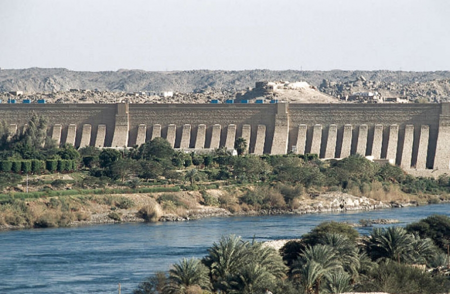
The HAD was constructed on the River Nile, 7 km south of Aswan.
It is a rock® ll dam with grout curtain and clay core.
Its total length is 3600 m and its height 111 m above the river bed.
The storage capacity of its lake is 162 km3. Its hydropower station capacity is 109 kWh per year.
The main aims of the construction of the Aswan high dam can be summarized as follows: · full control of the Nile ¯ ow at Aswan in the far south of Egypt; ·
regulation of the discharge downstream of the dam to match the actual water needs for different requirements; · protection of the Nile Valley and Delta from high ¯ oods and drought hazards that could persist for several consecutive years; ·
generation of cheap and clean hydroelectric power; · realization of horizontal land expansion by reclaiming new lands; · change in the system of basin irrigation (one crop per year), to perennial irrigation (two or more crops per year); ·
expansion in rice and sugar-cane cultivation to limit imports; ·
improvement of navigation through the Nile and navigable canals; and · realization of great ¯ exibility in agricultural planning, crop patterns and intensi® ed agriculture.
Social and Economical Impacts of Aswan high dam
Water Security and Availability The long-term or continuous storage policy and programme of the HAD lake (Nasser’ s lake) secured for Egypt an annual water quota of 55.5 km3 instead of a previous mean annual 48 km3, of which at least 22 km3 were to be released to the Mediterranean during the ¯ ood period (August± November). Sudan’ s quota was secured at 18.5 km3 instead of 4.5 km3.
This was concluded by a 1959 agreement between Sudan and Egypt, taking into consideration that the mean annual ¯ ow of the Nile at the borders is 84 000 MCM of which 10 000 MCM were deducted as mean water losses.
The agreement also contained future plans for development of Nile water by minimizing losses in the Upper Nile catch Egypt’s Aswan high dam 211 ment and increasing the water yield by 18 000 MCM annually through three main projects in Bahr El Gabel, Bahr El Gazai and Sobat catchments.
The construction of Aswan high dam and the 1959 agreement
managed to satisfy both Egypt and Sudan’s irrigation requirements for land under cultivation and plans for future land expansion.
The long-term storage policy and its applications managed to safeguard Egypt against famine and drought during the 10 consecutive years starting in 1978.
During those years more than 90 000 MCM of water were released from the reserve storage to compensate the de® cit in the Nile ¯ ow. Farmers were assured of having their water demands met at the right time.
They managed to irrigate their crops periodically in accordance with the schedule of plantation and growth till harvesting time, giving a very high yield of crop production in spite of poor yield of the catchment during those years.
It is also worth noting that by the construction of the Aswan high dam, the Egyptian Nile Valley and Delta were completely safeguarded against the perils of inundation due to the high ¯ oods of 1964, 1975 and 1988.
Land Reclamation The water secured by the long-term storage of the Aswan high dam
was the main factor that allowed the government of Egypt to ful® l its programme of horizontal land expansion.
About 2 million feddan (acres) were reclaimed, irrigated and cultivated using the water made available by the Aswan high dam reservoir.
This area encompassed lands in the East, West and Middle Delta and along the Nile Valley close to the old land.
About half a million families were settled on these new lands.
The opportunity was then open for new employment and additional production, especially of foodstuffs of which Egypt is in dire need to cope with the increasing population and food consumption and to minimize food imports.
Conversion of Basin Irrigation to Perennial Irrigation Approximately 1 million feddan, mostly in Upper Egypt, used to be irrigated by ¯ oodwater by the `basin irrigation’ method, through which only one crop per year was produced.
These lands were changed completely to perennial irrigation, whereby water is available at any time throughout the year, thus producing two or more crops annually.
This means that the crop area was doubled or tripled in these regions. The people living on these lands were completely settled there, leading a better life with higher yields and production.
Increase in Irrigated Land Yield The controlling of the River Nile ¯ ow by the HAD has secured a steady and continuous ¯ ow of water in adequate quantities that reaches all the arable land at the right time, particularly in summer when the natural ¯ ow of the Nile is much less than irrigation requirements.
This availability of water has secured ¯ exibility of agricultural planning, crop patterns and crop rotation.
As a result, the cropping area has risen to about 14.0 million acres compared with about 9.3 million acres in 1952.
The yield production per feddan (acre) has increased tremendously since construction of the Aswan high dam. 212 M. A. Abu-Zeid & F. Z. El-Shibini Increase in Rice and Sugar-cane Areas To satisfy crop requirements for local consumption, and the limitation of imports, it was possible to increase the areas cultivated with rice and sugar-cane.
With regard to rice,
it was estimated during the planning phase of the HAD to increase the area from 200 000 acres to 700 000 acres. In fact, this acreage has been surpassed with production of about 4 million tons of rice.
Land under sugar-cane production has also increased from 92 000 acres in 1952 to 275 000 acres.
The sugar factories in Upper Egypt are now working at full capacity and have been newly extended.
There is now a trend to expand sugar beet to replace sugar-cane gradually to save water consumption, and also to limit the area of rice to 700 000 acres.
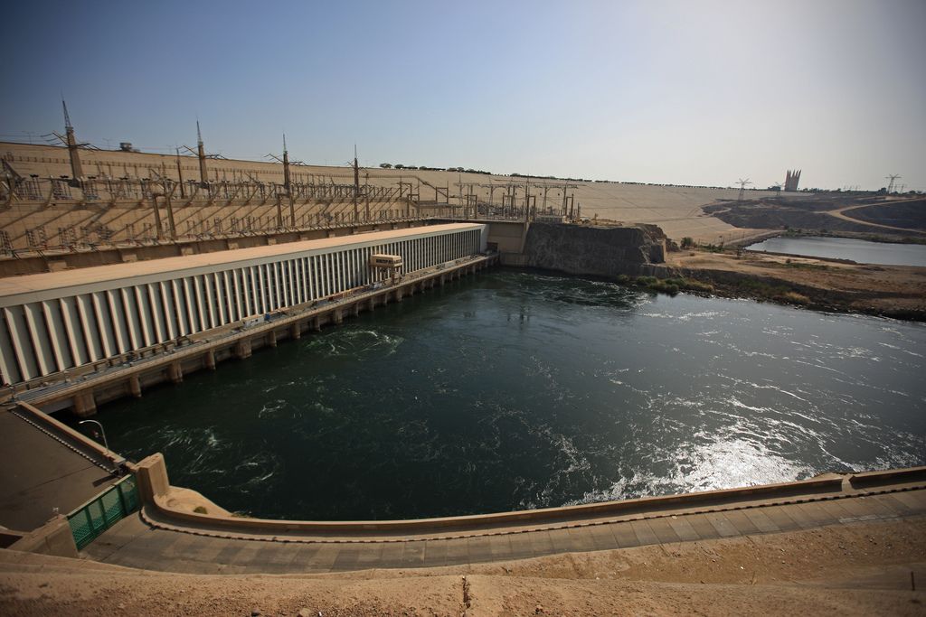
Hydropower The HAD is equipped with hydropower plant with installed capacity of 2.1 million MW and power generation of 10 000 MkWh yearly.
The power station comprises 12 generating units.
The ® rst unit was put into operation on 15 October 1967, a few months after the Arab± Israeli war in June.
This was a very hard and critical time when Egypt’ s economy had suffered high losses from the war and the Israeli occupation of Sinai with its oil wells and coal quarries, and consequently thermal power generation had been affected by the resultant shortages.
The HAD hydropower plant
began generating power at that time with an output of 71 MkWh in 1967, and gradually increased production to about 3700 MkWh in 1972 against a total power generation in Egypt of 7400 MKWh, i.e. about 50% of total power generated at that time.
Production by the HAD hydropower plant is now about 8000 MkWh/year. Its power generation has been successfully used in the electri® cation of Egypt’ s countryside which comprises more than 4500 villages, and the running of many old and new factories and pumping stations for irrigation and drainage.
In addition it has encouraged an increasing pace of industrialization and a rise in the standard of living, promoting culture, education and civilization throughout Egypt, particularly in rural areas.
The HAD has moreover improved the ef® ciency and the extension of the Old Aswan Hydropower stations (1 and 2) with total hydropower generation of about 10 000 MkWh/year, which is about 23% of the total power generated in Egypt.
Navigation and Tourism Improvement Navigation along the river has been improved, both upstream and downstream of the dam to the Mediterranean.
This has resulted in an increase in the ef® ciency of transport economics. Recently, sailing along the Nile from Cairo to Aswan has become very popular and has attracted many groups of tourists from all over the world particularly in winter.
The HAD and its surroundings have become an area of interest and attraction to many tourists. The annual number of tourists to Aswan has risen from 80 000 in 1960 to about 300 000 in recent years.
The HAD and ancient monuments in the area have caused Aswan province to become very attractive and promising for tourism and recreation year-round. Egypt’s High Aswan Dam 213 Fisheries and Fish Industries Fisheries have developed rapidly in Nasser’ s lake with annual production of about 35 000 tons. Factories for the ® shing industry and packaging are now in operation in the vicinity.
Resettlement of Nubians
and Monuments Nubians used to live around the stretch of the Nile about 350 km upstream of the Old Aswan Dam in the reservoir area, though they led a very hard life in small communities.
The construction of the Old Aswan Dam and its subsequent heightening twice led them to change their location or emigrate to the cities of Lower Egypt.
Because the HAD reservoir was expected to rise gradually to higher elevations, it was decided to resettle the Nubians to a new area downstream of the dam. The new settlement area was not far from the areas they used to live in, where 28 000 acres of fertile land was reclaimed and infrastructures and other services were supplied.
Some 25 000 houses were built among 33 villages which were given the same names as the old Nubian villages. The villages were built in the same order as beforehand.
After about 30 years, the social impact on the migrants has been viewed remarkably positively by the population concerned.
Other Environmental Considerations
In spite of the tremendous positive social and economic impacts of the HAD on Egypt’ s economy and development, criticisms of the project were one-sided looking at other environmental issues that it was considered should be managed, controlled or mitigated within a few years of project operation.
The issues of hot debate and how they were controlled and dealt with are set out below.
Siltation and Sediment Trapping Before the construction of the HAD, the discharges passing Aswan were between 600 and 13 000 m3/s, and are now regulated between 700 and 2800 m3s.
The water released to the Mediterranean used to be about 32 km3 mean annually and is now limited to about 300 million m3 during winter closure to satisfy the needs of navigation, industrial and drinking requirements and the prevention of intrusion of saline water from the sea to northern delta. The Nile used to transport 90% of suspended matter during the ¯ ood season.
The continuous monitoring of Nile suspended sediment (SS) year-round led to the conclusion that the SS passing Aswan was about 134 million tons on average.
Siltation of the HAD lake was studied while designing the project.
It was estimated that the amount of sedimentation in the reservoir would be about 60 million m3 annually.
Thus, dead storage of capacity of 31 km3 was allocated for silt deposition (dead storage) for a time span of about 500 years. Since 1968 (when the whole ¯ ood was reserved), the SS has retreated to the upstream reach.
Observations have shown that SS settling is at a distance not less than 250 km upstream of the dam.
Monitoring of reservoir sediment has shown that the mean annual rate is about 60± 70 million m3 annually, which is within the design considerations.
Degradation in River Courses Downstream of the HAD It was predicted during the studies for the HAD project that degradation along the river course would take place due to the fact that the water released downstream of the HAD would be free from SS and hence the relative geological balance of the river bed would be disturbed.
The prediction of degradation rate, its effect over the river’ s course and the barrages constructed on it was a very dif® cult task.
Comprehensive studies began in 1954 taking into consideration the discharges, velocities, the SS, river bed constituents, hydrographic surveys and other characteristics of the river regime.
Since then, many experts have estimated the overall degradation, its rate and the drop in water levels. The predictions of these experts were extremely different, due to the use of different methodologies and assumptions.
The predictions of degradation and drop in water level downstream of each barrage ranges from 10 to 2 m. According to observations, practice and management, the actual drop in water level due to degradation is in the range of 0.7± 0.3 m.
There is no longer any noticeable degradation.
Water Losses from the HAD Reservoir Before the construction of the HAD, many debates had been raised about the estimation of water losses by evaporation, seepage and absorption.
The seepage losses had been the great issue of debate. The estimations of total annual water losses were in the range between 24 km3 and 10 km3/year according to water levels and time of reservoir ® lling.
Studies of geology, hydrogeology etc. of the reservoir area proved that seepage losses at maximum reservoir elevation would be within 1.0 km3.
The mean evaporation losses for mean reservoir levels were estimated at 10.0 km3/ year.
Since construction of the HAD,
the losses are calculated using the water balance method and range between 7 and 12 km3 which is within the estimated values of studies and designs.
Monuments The reach from Old Aswan Dam to about 250 km3 to the south contained very important temples and monuments which were considered to be common heritage (about 17 temples), and thus it was decided to save all these monuments from inundation.
UNESCO, donors and the Egyptian authorities were involved in safeguarding the monuments by transferring the temples to higher elevations.
The most impressive ones are Abu-Simbel, Philae, Kalabsha, Amada and others,
which are the attractions for promoting the tourism industry in the vicinity.
Underground Water Regime To study the underground water regime, piezometers and observation wells were installed before the construction of the HAD.
The levels of piezometric Egypt’s Aswan high dam 215 heads were recorded in 1962 and 1964 (before construction of the HAD) and in 1968 and 1970 (after construction of the HAD).
It was concluded that following construction of the HAD, the underground water levels was affected by intensive irrigation and is approaching some steady-state condition, and the iso-salinity contour lines are moved seaward.
Tile drainage had a remarkable impact in improving soil moisture and land productivity. Water Quality In-dam reservoir.
From water samples taken monthly from the reservoir, it was noticed that the TDS (total dissolved solids), do not increase with time (about 170 mg/l) and other water quality parameters are very satisfactory.
Nile downstream of the High Dam.
The TDS before construction of the HAD used to be 120 mg/l in September and 230 mg/l in June every year.
After construction of the HAD, the TDS are in the range of 185 mg/l. A program for continuous water sampling by specialists from the Ministry of Public Works and Ministry of Health is carried out to monitor the water quality.
Aquatic Weeds In HAD reservoir.
The data collected in the annual mission survey for the lake have shown that weeds growing as ¯ oating, submerged or emergent are the same regional plants noted before construction of the HAD. Nile course, irrigation and drainage system downstream of the HAD.
The irrigated land in Egypt is about 7.8 million acres.
The canal system of irrigation and drainage totals about 50 000 km. Before the construction of the HAD, the maintenance of this system was mainly by the dredging of sedimentation.
After construction of the HAD,
the system suffered from growing aquatic weeds in the waterways.
The reason for weed growth is that water released from the HAD throughout the year is clear and free from SS and hence sunlight penetration and moderate weather encourage the growth of weeds.
Also the decrease of water ¯ uctuation and increase of fertilizers accelerated the growth of weeds. The total length of the infested waterways is about 27 000 km. Since 1975, the Ministry of Public Works have developed many successful means to control the aquatic weeds.
At present, three major types of aquatic weed control are carried out in Egypt by manual, mechanical and biological methods and the weed growth has been fully controlled.
Impact of Loss of Nile Sediment
Load over the Arable Land Since construction of the HAD, the water released from the dam has been almost free from SS.
The percentage of Azote in Nile sediment is about 0.13%, and only one-third of this amount is useful for feeding the crops.
The total amount of useful Azote was estimated, taking into consideration the fact that most of the SS used to settle over the basin irrigation areas which are no longer available since changing the system of irrigation over these areas to perennial irrigation.
It was concluded that loss of Azote is about 1800 tons and this was replaced by lime nitrate fertilizers.
Endemic Diseases
Not a single case of malaria has been reported along the HAD reservoir.
The Egyptian authorities, in collaboration with the WHO, have established several stations to monitor the disease and the anopheles mosquito has not been found.
Although bilharzia is a very old problem in Egypt, particularly in the delta, it was expected to spread in Upper Egypt over the land changed from basin irrigation to perennial irrigation.
The Egyptian authorities and UNDP have organized a large programme for bilharzia treatment and combat.
Implementation of this program, together with improvement of canal and drain design, construction of tile drainage and weed control were effective in controlling the hosts of bilharzia parasites.
With regard to the HAD lake, the conditions of the water regime do not permit the host snails of bilharzia to exist.
Mediterranean Seashore Erosion
The Nile Egyptian Delta was formed as a result of silt deposition in several old mouths of the Nile where it ¯ ows into the Mediterranean and the coast has assumed its shape since very ancient times without further additions.
The coast defended itself and a quasi-dynamic equilibrium between different metrological factors was established.
Although observation in 1898 had revealed erosion of the seashore in some localities, some critics have attributed shoreline erosion to the construction of the HAD.
Nevertheless, a study was carried out with the assistance of the UNDP to study the problem. Design and execution of some remedial works took place.
In 1981, the SPA (Egyptian Shore Protection Authority) was established to study and deal with the problem as a socioeconomic issue.
Most of the eroded shore areas had had very successful protection works carried out.
Seismic Activity The surprise occurrence in November 1981 of moderate earthquakes of magnitude 5.3 Ms,
about 55 km south-west of the HAD, generated signi® cant concern among the Egyptian people with regard to safety of the dam.
It was recommended that a comprehensive earthquake activity evaluation program be carried out to assess the stability of the dam during the maximum earthquake that could occur along faults in the Aswan and Red Sea areas.
A comprehensive body of work to identify areas of seismic geology, engineering and other works was thoroughly conducted to evaluate the seismic safety of the HAD.
The study concluded that Aswan region is located in a tectonically stable area, and future earthquakes that could produce ground motions would not affect the integrity or safety of the HAD.
With respect to reservoir-induced seismicity, it was concluded that the possible effects of seismicity triggered by the reservoir are insigni® cant to the seismic safety of the HAD and that it does not increase the probability of exceeding the safety evaluation earthquake at the HAD. Egypt’s High Aswan Dam 217 Summary and Conclusion The HAD has been considered as one of the landmarks in Egypt’ s struggle for social and economic development.
The dam has played a significant role in comprehensive control of the Nile flow and the strengthening of water management and optimization of its use.
These achievements have had positive impacts on agricultural production, with horizontal expansion in newly reclaimed and irrigated land and new communities and employment opportunities.
Suffecient, steady and timely water availability, with cropping pattern ¯ exibility and diversity, has brought great bene® ts to the agriculture sector. Hydropower generation through the HAD plant has played a very important role in rural areas, industries, and the civilization, education and welfare of the Egyptian people.
Protecting and safeguarding Egypt from devastating goods and the perils of droughts, famines and starvation are an asset of the HAD that could not be estimated or financially appraised.
The bene® ts and highly positive impacts of the HAD on Egypt’s social and economic developments greatly outweigh any unfavorable or environmental consequences, which have been successfully controlled and properly managed and dealt with.
Past and the present Egyptian generations,
and doubtless future generations, will recognize that the building of the HAD, in spite of tough opposition, and unfair and unjusti® ed con¯ ictsÐ within and beyond EgyptÐ to hinder the implementation of the project, to have been a great challenge to the Egyptian people.
In their minds and hearts, the success in building and operating the HAD represents to the Egyptian people their dignity, insistence, will and determination to their bene® ts and interests.
These observations are based on the fact that HAD is the only central bank of water for Egypt and the only active heart, for Egypt, that continues round the clock pumping puri® ed blood (water) into the arteries of more than 150 000 km of main, secondary, tertiary and quaternary canals that feed every inch of the irrigated land, besides ful® lling requirements for many purposes.
Bibliography Abul-Atta A. (1978) Egypt and the Nile after the Construction of High Aswan Dam (Cairo, Ministry of Irrigation).
El Salty, M.T. & Younes (1993) HAD hydropower generation in Egypt, paper presented to ICOLD Symposium, Cairo. Hefny, K. (no date) Groundwater Regime after the Construction of the High Aswan Dam (Cairo, Groundwater Research Institute).
Kenawy, I.Z. & Shenouda, W.K. (1975) Ecological, Social and Economical Impacts of Damming the Nile at Aswan (New Delhi, International Commission on Irrigation and Drainage (ICID)). Khattab, A.F. & El-Gharabiy Z. (1986) Management of Aquatic Weeds in Irrigation Systems with Special Reference to the Problem in Egypt (Cairo, Aquatic Weeds Research Institute).
Shalaby, A.M. (1988) High Aswan Dam and environmental impact, paper presented to ICOLD Congress, San Francisco. Shalaby, A.M. (1993) Socio-economic impacts of High Aswan Dam, paper presented to ICOLD Symposium, Cairo.
Shalash, S. (1986) The impacts of large water projects on the environment, paper presented to Ant. Symposium, Unesco Headquarters, Paris.
Tetra Tech. (1985) Shore Protection Master Plan for the Nile Delta Coast, Cairo. Woodward-Clyde Consultants (1985) Earthquake Activity and Stability Evaluation of Aswan High Dam (San Francisco, CA, Woodward-Clyde).
